Camino Francés Stage32: Azúra
Trail Notes
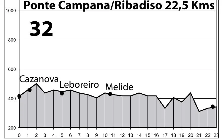
Camino Francés Elevation
Whatever it is, the way you tell your story online can make all the difference.
-
Distance: 28.5 km - 29.5 km (17.8 - 18.3 miles)
Estimated Time: 6 to 8 hours of walking
Elevation Gain: ~660 m to 730 m (2,160 - 2,400 ft)
Difficulty: Moderate to Demanding (due to continuous rolling ups and downs and length)
-
San Xulián do Camiño (Km 5.5) – Small hamlet with a 12th-century Romanesque church.
Melide (Km 14.4) – Halfway point, café and water. The town is famous for pulpo á feira (octopus) and where the Camino Primitivo joins.
Boente (Km 20) – Small village featuring the Church of Santiago, water and cafés.
Ribadiso (Km 25.4) – Water and cafés.
-
Albergue San Francisco 12€ recommend. On the Camino, near shops and cafés.There's a wonderful tea shop across the square.
Cruce de Caminos:17€
Pension Arcano; 35-45€
-
Water Safety: There are many water fountains along this path. Be sure these fountains say"Agua Potable" (drinking water). If it has been raining, please use bottled water. Many pilgrims were having stomach problems. The consensus was the water.
The infrastructure is significant. If you’re trying to maintain the Camino quiet, try to stay outside the typical Camino stages.

Camino Francés Portomarin Mino River Belzar Reservoir
JOURNAL
Still raining, two days left until Santiago. I’ve noticed something shifting among the pilgrims I’ve walked alongside these past six weeks—everyone is quieter, less talkative, - maybe the rain is part of it, setting a mood none of us chose. It’s strange to think about the Camino I’ve left behind: the Pyrenees, the romantic vineyards, the hot, flat Meseta, and endless fields of bright yellow rapeseed. Now, I’m hiking through mud, rain and cold. This is the final stretch before the Camino lets me go. I’ve walked through every kind of weather, and this is the one it saved for last—That Eva!